 TRAVELINGOZ .COM

AUSTRALIA FROM SPACE
The images below are courtesy of NASA.
Description: (above)
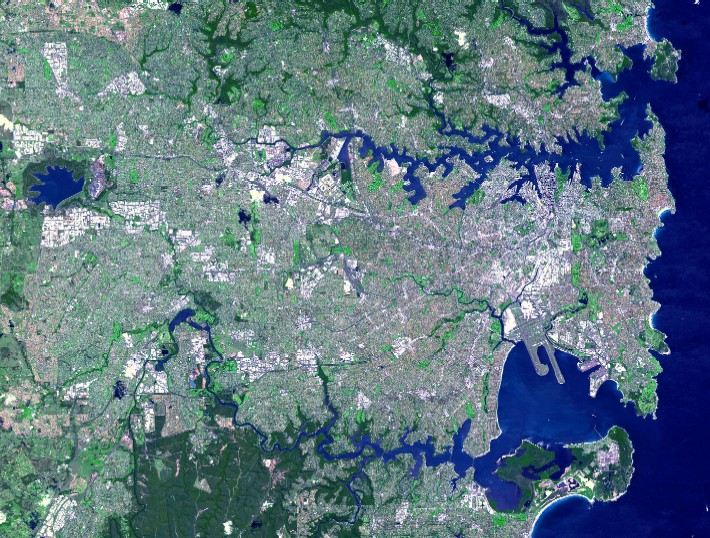
Home to more than four million people from over 100 countries, Sydney is the
largest and most cosmopolitan of Australia's cities. This simulated true-color
Advanced Spaceborne Thermal Emission and Reflection Radiometer (ASTER) image
shows the Sydney metropolitan area on October 12, 2001, and covers an area of 42
by 33 kilometers. The image displays the concentrated development of the urban
area. Sustainable use of water and effective water management are prime concerns
for the area. The city has developed numerous dams and water storage areas,
including the Prospect Reservoir, located at the upper left edge of the image.
Built in 1888, this reservoir is one of Sydney’s oldest and was once the major
water storage facility for the city.
Surrounding Sydney on all
sides except its shoreline are National Parks and Preserves, and at the bottom
of the image, the forested terrain of the park system south of the city can be
seen. Sydney has two superb natural harbors: Botany Bay to the south and Sydney
Harbor to the north. The strips of land extending south into Botany Bay are the
runways of the Sydney Airport. Inhabited by the Aboriginal people for at least
50,000 years, Sydney was visited by the English captain James Cook in 1770 and
later settled in 1788 by another English Captain, Arthur Phillip, and 11 ships
filled with over 1000 passengers, which eventually came to be known as the First
Fleet.
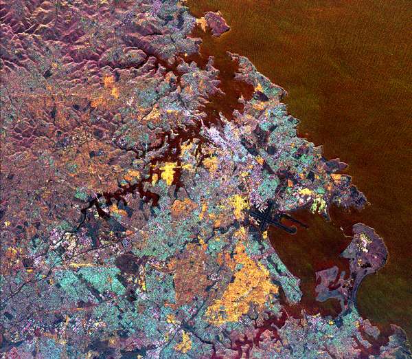
This spaceborne radar image is dominated by the
metropolitan area of Australia's largest city, Sydney. Sydney Harbour, with
numerous coves and inlets, is seen in the upper center of the image, and the
roughly circular Botany Bay is shown in the lower right. The downtown business
district of Sydney appears as a bright white area just above the center of the
image. The Sydney Harbour Bridge is a white line adjacent to the downtown
district. The well-known Sydney Opera House is the small, white dot to the right
of the bridge. Urban areas appear yellow, blue and brown. The purple areas are
undeveloped areas and park lands. Manly, the famous surfing beach, is shown in
yellow at the top center of the image. Runways from the Sydney Airport are the
dark features that extend into Botany Bay in the lower right. Botany Bay is the
site where Captain James Cook first landed his ship, Endeavour, in 1770. The
image was acquired by the Spaceborne Imaging Radar-C/X-band Synthetic Aperture
Radar (SIR-C/X-SAR) on April 20, 1994, onboard the space shuttle Endeavour. The
area shown is 33 kilometers by 38 kilometers (20 miles by 23 miles) and is
centered at 33.9 degrees south latitude, 151.2 degrees east longitude. North is
toward the upper left. The colors are assigned to different radar frequencies
and polarizations as follows: red is L-band, vertically transmitted and
horizontally received; green is C-band, vertically transmitted and horizontally
received; and blue is C-band, vertically transmitted and received. SIR-C/X-SAR,
a joint mission of the German, Italian and United States space agencies, is part
of NASA's Mission to Planet Earth.
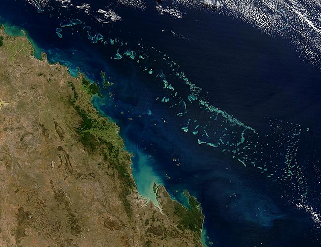
Colonies of coral appear
vibrant blue green in this image of Australia's Great Barrier
Reef. Stretching over 2000 kilometers along the northeast coast
of Australia, the Great Barrier Reef is the largest coral system
that has ever existed. It is made up of about 2,900 reefs,
though only about six percent are coral reefs. Teaming with
life, the region is home to a wide variety of marine animals
including over 1500 species of fish, sea snakes, turtles, birds,
mollusks, and dugongs. Broad Sound cuts into the Queensland
coastline towards the southern edge of the reef in this image,
captured by NASA's Terra satellite on July 26, 2003.
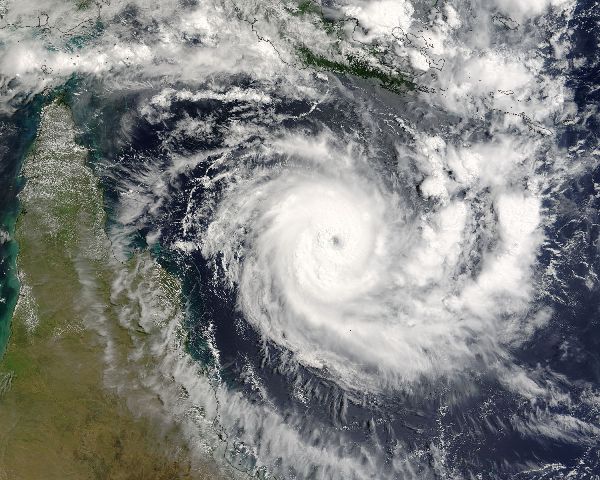
Tropical Cyclone Ingrid is
slowing inching its way west, southwest over the Coral Sea
towards Queensland, Australia. The storm developed into a
cyclone early on March 6, 2005, and quickly intensified into a
massive Category 4 storm. On March 7, when the Moderate
Resolution Imaging Spectroradiometer on NASA’s Terra
satellite captured this image, the storm had winds of 220
kilometers per hour (140 mph) with gusts to 270 kph (170 mph).
The Joint Typhoon Warning Center expects Ingrid to continue to
intensify as it moves closer to northeastern Australia, possibly
coming ashore on March 9, 2005.
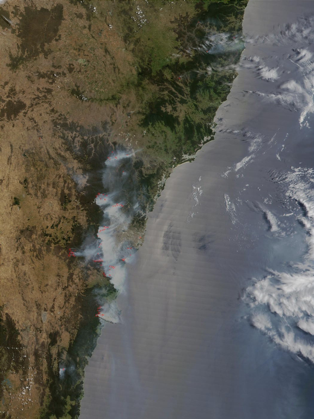
Description:
(above) This true-color image over Sydney, Australia, was taken on December 29,
2001, by the MODIS sensor flying aboard NASA's Terra satellite. The scene shows
more than a dozen wildfires (red pixels) burning around the city, while their
grey smoke plumes fill the skies.
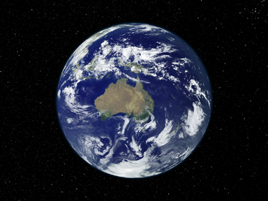
Description:
(above) Fully lit full disk image pair centered on
Australia and Oceania.
Description:
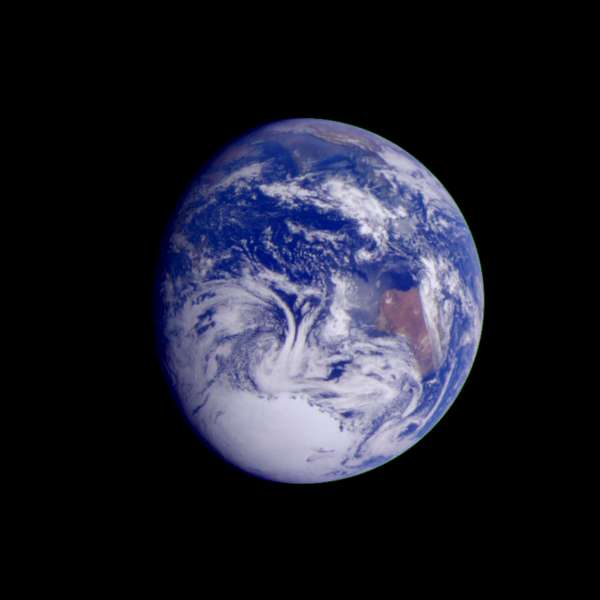
(above)
This color image of the Earth was obtained by the Galileo spacecraft on Dec. 11,
1990, when the spacecraft was about 1.5 million miles from the Earth. The color
composite used images taken through the red, green and violet filters. India is
near the top of the picture, and Australia is to the right of center. The white,
sunlit continent of Antarctica is below. Picturesque weather fronts are visible
in the South Pacific, lower right. This is a frame of the Galileo Earth spin
movie, a 500-frame time-lapse motion picture showing a 25-hour period of Earth's
rotation and atmospheric dynamics.
 Top of page
Page updated
April 26, 2025 04:36:01 PM